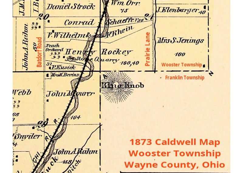
Blue Knob once an island unto itself south of Wooster
In Benjamin Douglass’ History of Wayne County, Ohio, published in 1878, he provides a description of the Killbuck Creek, the Apple Creek, and the land along Killbuck Creek that lies between Wooster and Shreve.
Douglass describes the Killbuck Creek as a river. Indeed, he uses the term “Killbuck River” multiple times in his book. He wrote what the early settlers found when they first gazed upon that body of water. They saw a deep, wide stream, set in a broad, flat valley of its own creation.
They also saw evidence of how its course has changed over time. They found evidence of the influence, sometimes radical influence, of the Apple Creek on the Killbuck. While the Killbuck, with its powerful volume of water, is described as sluggish, the Apple Creek, when fortified with heavy rain, becomes a raging torrent and the source of much of the silt, gravel, sand and clay that often filled the old path of the Killbuck, forcing the creation of new one.
Douglass also described a great beaver dam on the south side of Wooster. It was something of a curiosity and was locally known as “Beaver Dam.” Evidently, it spanned one of the ancient channels that had been filled by one of these great flooding events.
The land of the valley was seen as an ancient lake bed, formed by the combined force of Killbuck Creek and Apple Creek. Log jams had created a perennial lake, making the land undesirable by early settlers. For even when the water was drained off, the land remained so wet that it would quake under foot and, if punctured, would seep streams of water.
There were islands in the ancient lake, many small, a few much larger. One of the largest of these islands was known as “Blue Knob.” This island, located south of Wooster in Franklin Township, protruded high above the highest flood waters — so much so that stands of oak, sugar maple, hickory, ash and cherry, as on the mainland, were thriving there. So Blue Knob was never inundated. It was a refuge of sorts.
This was particularly true in the early spring when the area was starting to warm and the ice that had been a great highway for people and animals alike to roam freely between the mainland and the islands began to break up. Then the islands became a refuge for a menagerie of animals that were common at that time. Some of those animals are very familiar to us today: deer, fox, raccoon, rabbits and squirrels. What was there then but not now? Elk, bears, cougars, wild cats (bobcats) and wolves were all present.
These islands, after the thaw, became a virtual smorgasbord for hunters. Easy hunting could be had because of the general hydrophobia of the fauna trapped there. So in these parts, early spring was a time of plenty for the indigenous people.
So where is Blue Knob? If it was such a prominent feature 200 years ago, shouldn’t it still be a prominent feature? If you look at the Caldwell map of Wooster Township, published in 1873, it was located in Franklin Township, where Prairie Lane Corporation is today. A company named Blue Knob Crushed Stone Company was formed in 1919 to harvest the limestone, sandstone and clay it was composed of. Today, Blue Knob is widely dispersed. The crushed limestone is in the regional road beds, and the fine lime was used in agriculture.
As time passed, hydro-engineering began to take place. Gradually, this great inland lake began to subside, thanks to a series of deep ditches to capture and guide the water away in a controlled manner. Not that flooding was eliminated, but it became far less commonplace and, when it did happen, far less destructive.
And the land that drew no interest from early farmers soon became some of the most fertile in the area.

